


CAMBRIDGE, Massachusetts—Kleinfelder has been the lead consultant for the City of Cambridge’s climate change adaptation efforts since 2012. The climate change team’s efforts have produced comprehensive models for climate change planning, including information on flooding risk. With Kleinfelder’s help, the City has put flooding maps and data in the public’s hands via development of the FloodViewer App.

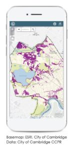 The FloodViewer App is an informational tool for the Cambridge community to assess climate change threats from flooding and to prepare for it by implementing specific strategies. Residents, business owners, civil servants, and facility managers can now open their smartphone browsers and access maps and data on present and future flood risks, down to the parcel level. The web application displays flooding information for present day, 2030, and 2070 planning horizons, including information for both 10-year and 100-year storms. In addition to modeled flooding data, existing FEMA flood zones and 1-foot elevation contours can also be displayed.
“We receive frequent requests from property owners, developers, and residents asking what level of flooding they should be preparing for. Now we can point people to the FloodViewer App, and provide them with the best available information,” said Kathy Watkins, City Engineer and Deputy Commissioner for the Public Works Department. “Not only do they get information on their specific property, but also the context of flood risks in the surrounding area. Working with Kleinfelder, we have also developed a brochure with critical information about steps people can take to protect their property.”
The FloodViewer App uses the City’s Esri ArcGIS Online platform, providing users a high level of detail and performance across both desktop and mobile devices.
The flood maps take into account the complex interactions between rivers, underground stormwater and combined sewer infrastructure, dam operations, pumping systems, and climate change projections for increased rainfall, as well as Sea Level Rise and Storm Surge.
The release of FloodViewer is expected to advance the City’s existing efforts in sharing data collected from the City’s Climate Change Vulnerability Assessment.
Institutional and industry leaders in Cambridge are using the City’s data to assess their own vulnerabilities and plan stormwater and landscape improvements on their campuses;
Developers are designing new buildings with future flood scenarios in mind; and
Neighboring communities are using the methods and data that Cambridge created to leapfrog forward in the adaptation planning process.
The FloodViewer App is just the beginning. “In the future, one could imagine integrating projected flood data in applications like WAZE to help improve the safety of drivers and increase the efficiency of emergency response operations during and after a flooding disaster,” said Aaron Doucett, Kleinfelder GIS Specialist, who helped develop the FloodViewer app.
Kleinfelder. Bright People. Right Solutions. Founded in 1961, Kleinfelder is a leading engineering, design, construction management, construction materials inspection and testing, and environmental professional services firm. Kleinfelder now employs more than 2,200 professionals and operates from over 75 office locations in the United States, Canada, and Australia. The company is headquartered in San Diego, California. Poised for growth, Kleinfelder continues to provide high-quality solutions for our diverse client base. Visit Kleinfelder.com or follow us on LinkedIn/Kleinfelder.